


Friday, July 08, 2005
Google Earth, I actually Used It
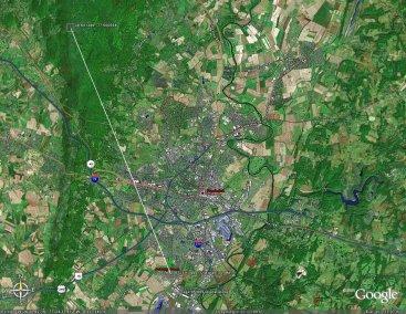
So I complained a lot about Google Earth a few days ago. Today, I actually made use of it. I was trying to pinpoint an APRS digipeater on the map when all I had was its latitude and longitude coordinates. After some conversion from degrees, minutes, and seconds to decimal degrees, I was able to do just that. Google Earth has a nice feature that will allow you to draw a line from one point on the map to another and measure the distance, so I used that to see how far I was from the digipeater. The white diagonal line is my measurement; I’m 9.72 miles away from the digipeater. I should be able to hit that on low power, but with my indoor antenna mounted horizontally on my air return vent, I can’t seem to get through, although I can hear it just fine. Hopefully when I get a more permenant antenna set up I’ll be able to turn the power down.
Subscribe to:
Post Comments (Atom)
2 comments:
There is also another service similar to google earth it is located on microsoft's terra server it has got much better deal , really good if you live in Usa, you can search for it on google.
I started playing around with google earth a couple of weeks ago. it is fun to play around with but to much data is still unavailable.
Post a Comment